| Übersicht - alle Ereignisse | Ganzseitenversion dieser Seite |
Die Berechnung der partiellen Bedeckung
Year  M  D  h  m  s  Event Type     Ph   Dur dMag  %Ill   Sep  PA  MinD      h  m  s   h  m  s   h  m  s   h  m  s   h  m  s   h  m  s   h  m  s
2009  5 23  0 37 35  (II) occ (III)  P   333  0.2  79.8  94.8  68  0.507 |             0 34 49             0 37 35             0 40 21
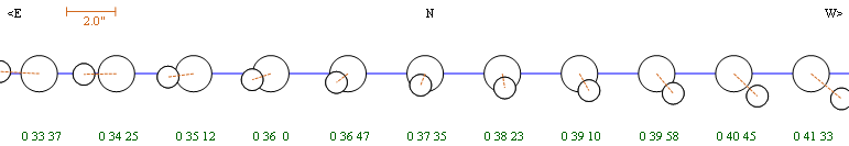
Daten und Grafik erstellt mit Occult 4 von Dave Herald
Jupiter System - 2009/05/23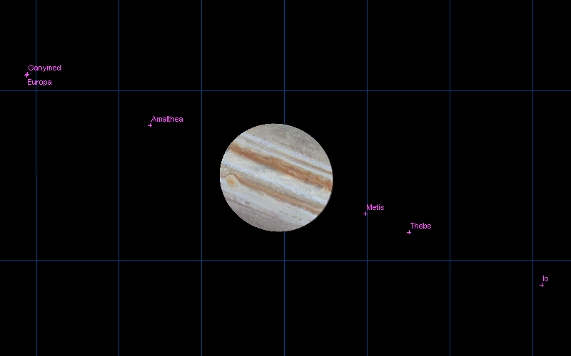
Sternkarte erstellt mit Guide 8 von Bill J Gray.
Der Aufbau für die Aufzeichnung der Bedeckung
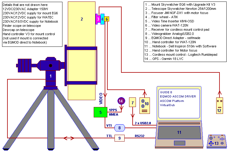
CCIR (PAL) Vollformat Videobild 768x576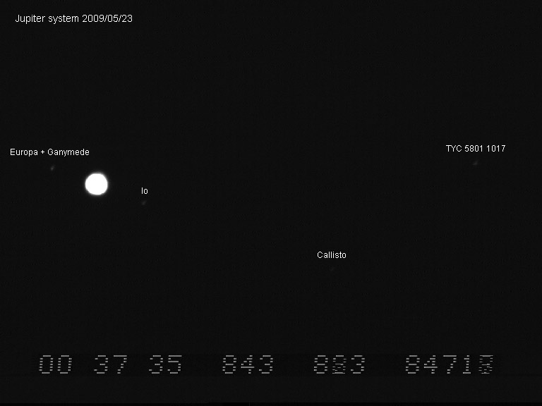
Limovie Einstellungen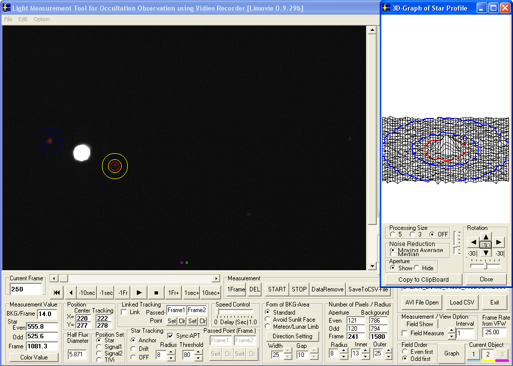
MUTUAL OCCULTATION - REPORT
MUTUAL OCCULTATION - REPORT
EAON & IOTA-ES
EUROPEAN ASTEROIDAL OCCULTATION NETWORK
INTERNATIONAL OCCULTATION TIMING ASSOCIATION EUROPEAN SECTION

1.DATE: 2009/05/23
Event: Jupiter system 2O3; Europa (II) occults Ganymede (III)

2.OBSERVER:
Name: Gerhard Dangl
Phone: ++43-(0)2842-53908
Address: AUSTRIA, A-3830, Nonndorf 12
E-mail: gerhard@dangl.at

3.OBSERVING STATION:
Nearest city: Waidhofen/Thaya
Latitude:  N 48 47 28.4 (WGS84)
Longitude: E 15 13 59.8 (WGS84)
Altitude:  601m         (WGS84)
Single/Multiple: Single

4.TIMING OF EVENTS:
Type of event:
"S"tart observation; "I"nterrupt-"s"tart; "D"isappearance;
"B"link; "F"lash; "E"nd observation; "I"nterrupt-"e"nd;
"R"eappearance; "O"ther (specify)

Recording time HH:MM:SS UTC
S:    00:29:59
E:    00:40:30

5.TELESCOPE:
Type: Newton
Focal length: 1200mm
Aperture: 254 mm
Magnification: video/primary focus/FOV 18.3'x13.7' (768x576, 1.43"x1.43" per pixel)
Mount: Equatorial
Motor drive: Yes

6.TIMING & RECORDING:
Timekeeping: GPS 1PPS Garmin 18x LVC + KIWI-OSD
Sensor/Camera: WAT-120N, CCIR, 1/2" Sony CCD-Sensor ICX419ALL, GAMMA=OFF (linear)
Mode of recording: It=20ms (50 Img/s), Video CCIR, AVI, YUY2, Huffyuv,
Device of recording: TIS DFG/USB2-lt Videograbber USB2.0, Notebook Harddisk
Time insertion: KIWI-OSD

7.OBSERVING CONDITIONS:
Atmospheric transparency: fair
Wind: 0 - 0.5 m/s
Object image stability: fair
Temperature: 280 Kelvin (+07 deg Celsius)

8.ADDITIONAL COMMENTS:
Object height above local horizon at recording start: 05 deg
Object height above local horizon at recording end:   07 deg

Only Clear glass filter (Astronomik) for CCD protection was used.

Video evaluation accomplished with VirtualDub1.8.6, AviSynth2.5,
Limovie0.9.29b, LimovieAverage and Excel

3-D Position and timing
Garmin GPS18x LVC
Receiving 10 satellites
Horizontal Dilution of Precision 0.9
Geoidal separation 44.5m (Altitude 556.4MSL + 44.5 = 600.9m in WGS84 datum)

Gerhard Dangl
gerhard@dangl.at
www.dangl.at/
Die Auswertung der Messdaten
Die Auswertung der Messdaten aus dem aufgezeichnetem Video erfolgte mit folgenden Programmen:
-VirtualDub
-Limovie
-Avisynth
-LimovieAverage
-Help text, using LimovieAverage with mutual events
Download der Messdaten und Ergebnisse im Excel file format
-Excel File, Raw Daten, 25 Messpunkte pro Sekunde (3.71 MB)
-Excel File, Binning 8 Datenpunkte (588 KB)
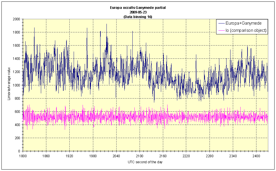
-Excel File, Binning 16 Datenpunkte (306 KB)
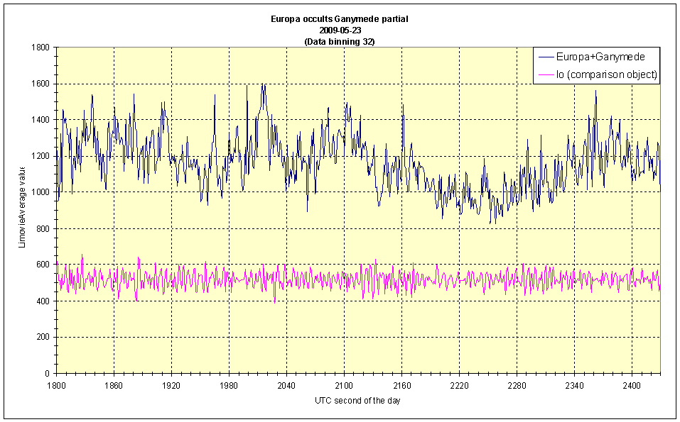
-Excel File, Binning 32 Datenpunkte (165 KB)
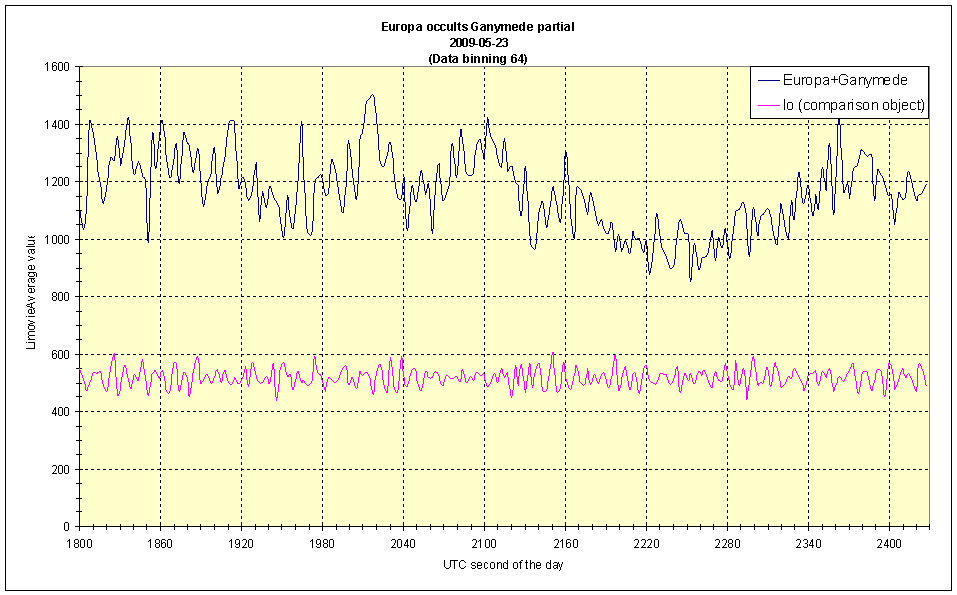
-Excel File, Binning 64 Datenpunkte (114 KB)
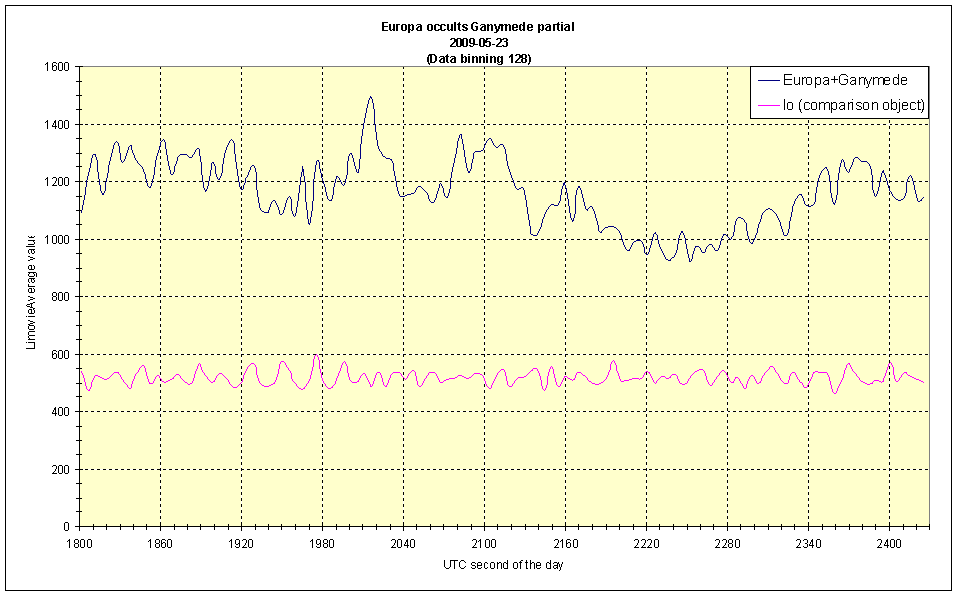
-Excel File, Binning 128 Datenpunkte (91 KB)
Die Diagramme aus den Excel files im Überblick
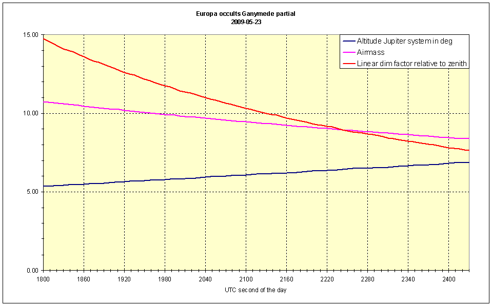
-Diagramm Jupitersystem, Horizonthöhe und airmass Zahl
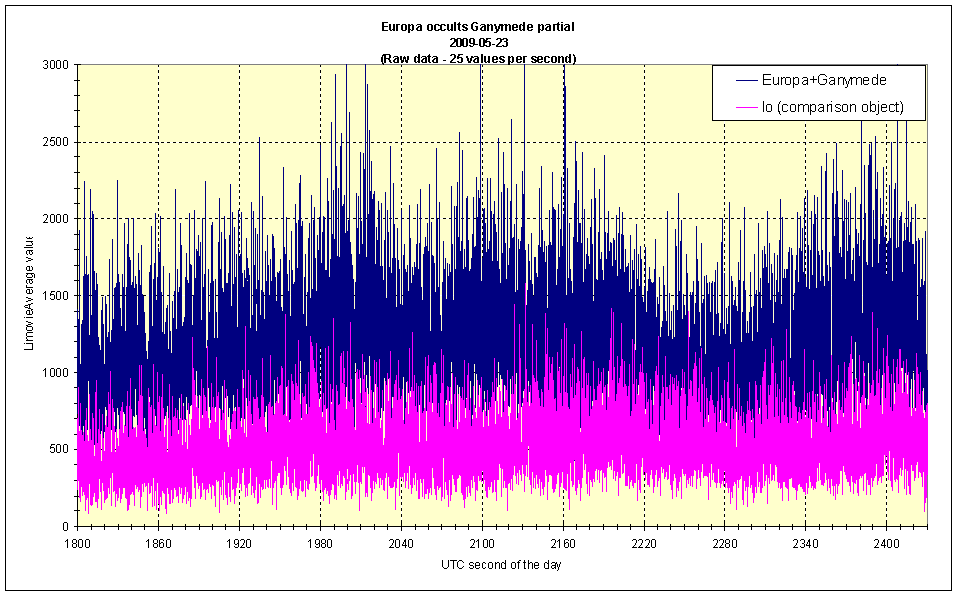
-Diagramm RAW Daten, 25 Messpunkte pro Sekunde
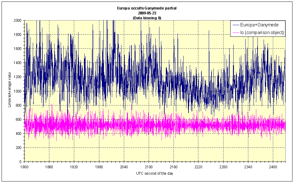
-Diagramm binning 8 Datenpunkte
-Diagramm binning 16 Datenpunkte
-Diagramm binning 32 Datenpunkte
-Diagramm binning 64 Datenpunkte
-Diagramm binning 128 Datenpunkte
 |
|
 |
|
 |
|
 |
|
 |
|
 |
|
 |
29. September 2009 |
|
Zur Startseite |