| Overview - all events | Frameless version of this page |
The prediction of the partial eclipse
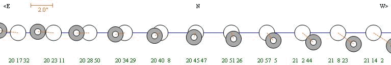
Year  M  D  h  m  s  Event Type     Ph   Dur dMag  %Ill   Sep  PA  MinD      h  m  s   h  m  s   h  m  s   h  m  s   h  m  s   h  m  s   h  m  s
2009  8 16 20 45 46  (I) ecl (III)   P  2373  0.5  62.6 137.8  68  0.443 |  20 26  0  20 32 41            20 45 46            20 58 51  21  5 33
Data and diagrams created with Occult 4 from Dave Herald
Jupiter system - 2009/08/16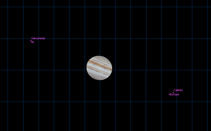
Starmap created with Guide 8 from Bill J Gray.
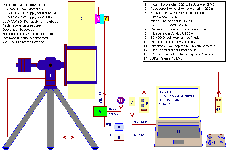
The setup for eclipse recording
CCIR (PAL) full size video image 768x576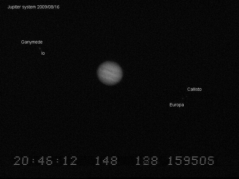
Limovie settings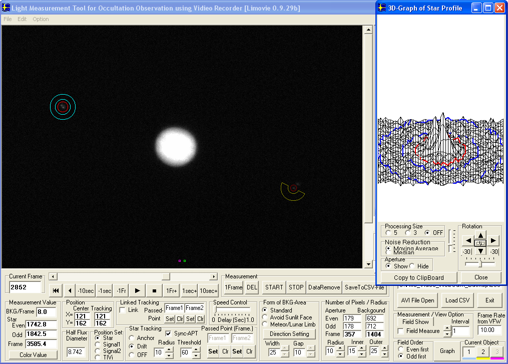
MUTUAL ECLIPSE - REPORT
MUTUAL ECLIPSE - REPORT
EAON & IOTA-ES
EUROPEAN ASTEROIDAL OCCULTATION NETWORK
INTERNATIONAL OCCULTATION TIMING ASSOCIATION EUROPEAN SECTION

1.DATE: 2009/08/16
Event: Jupiter system 1E3; Io (I) eclipsed Ganymede (III)

2.OBSERVER:
Name: Gerhard Dangl
Phone: ++43-(0)2842-53908
Address: AUSTRIA, A-3830, Nonndorf 12
E-mail: gerhard@dangl.at

3.OBSERVING STATION:
Nearest city: Waidhofen/Thaya
Latitude:  N 48 47 13.5 (WGS84)
Longitude: E 15 14 08.2 (WGS84)
Altitude:  595m         (WGS84)
Single/Multiple: Single

4.TIMING OF EVENTS:
Type of event:
"S"tart observation; "I"nterrupt-"s"tart; "D"isappearance;
"B"link; "F"lash; "E"nd observation; "I"nterrupt-"e"nd;
"R"eappearance; "O"ther (specify)

Recording time HH:MM:SS UTC
S:    20:04:54
E:    21:10:21

5.TELESCOPE:
Type: Newton
Focal length: 1200mm + Powermate 2.5x = 3000mm effective focal length
Aperture: 254 mm
Magnification: video/primary focus/FOV 7.3'x5.5' (768x576, 0.57"x0.57" per pixel)
Mount: Equatorial
Motor drive: Yes

6.TIMING & RECORDING:
Timekeeping: GPS 1PPS Garmin 18x LVC + KIWI-OSD
Sensor/Camera: WAT-120N, CCIR, 1/2" Sony CCD-Sensor ICX419ALL, GAMMA=OFF (linear)
Mode of recording: It=40ms (25 Img/s), Video CCIR, AVI, YUY2, Huffyuv,
Device of recording: TIS DFG/USB2-lt Videograbber USB2.0, Notebook Harddisk
Time insertion: KIWI-OSD

7.OBSERVING CONDITIONS:
Atmospheric transparency: bad
Wind: 0 - 0.5m/s
Object image stability: fair
Temperature: 290 Kelvin (+17 deg Celsius)

8.ADDITIONAL COMMENTS:
Object height above local horizon at recording start: 16 deg
Object height above local horizon at recording end:   22 deg

From video stream with 25 Img/s every second one image was captured.

IR pass filter with transmission edge of 807nm was used.

Video evaluation accomplished with VirtualDub1.8.6, AviSynth2.5,
Limovie0.9.29b, LimovieAverage 1.2.0.0 and Excel

3-D Position and timing
Garmin GPS18x LVC
Receiving 08 satellites
Horizontal Dilution of Precision 1.9
Geoidal separation 44.5m (Altitude 550.8MSL + 44.5 = 595.3m in WGS84 datum)

Gerhard Dangl
gerhard@dangl.at
www.dangl.at/
The evaluation of the measurement data
The evaluation of the measurement data from recorded video was done with the software packages below:
VirtualDub
Limovie
Avisynth
LimovieAverage
Help text, using LimovieAverage with mutual events
Measurement data and results in csv and Excel data format
CSV file, binning 1 second (234 KB)
Excel file, binning 1 second (705 KB)
CSV file, binning 2 seconds (117 KB)
Excel file, binning 2 seconds (439 KB)
CSV file, binning 4 seconds (59 KB)
Excel file, binning 4 seconds (306 KB)
The diagrams in an overview
Diagram binning 1 second - click for full size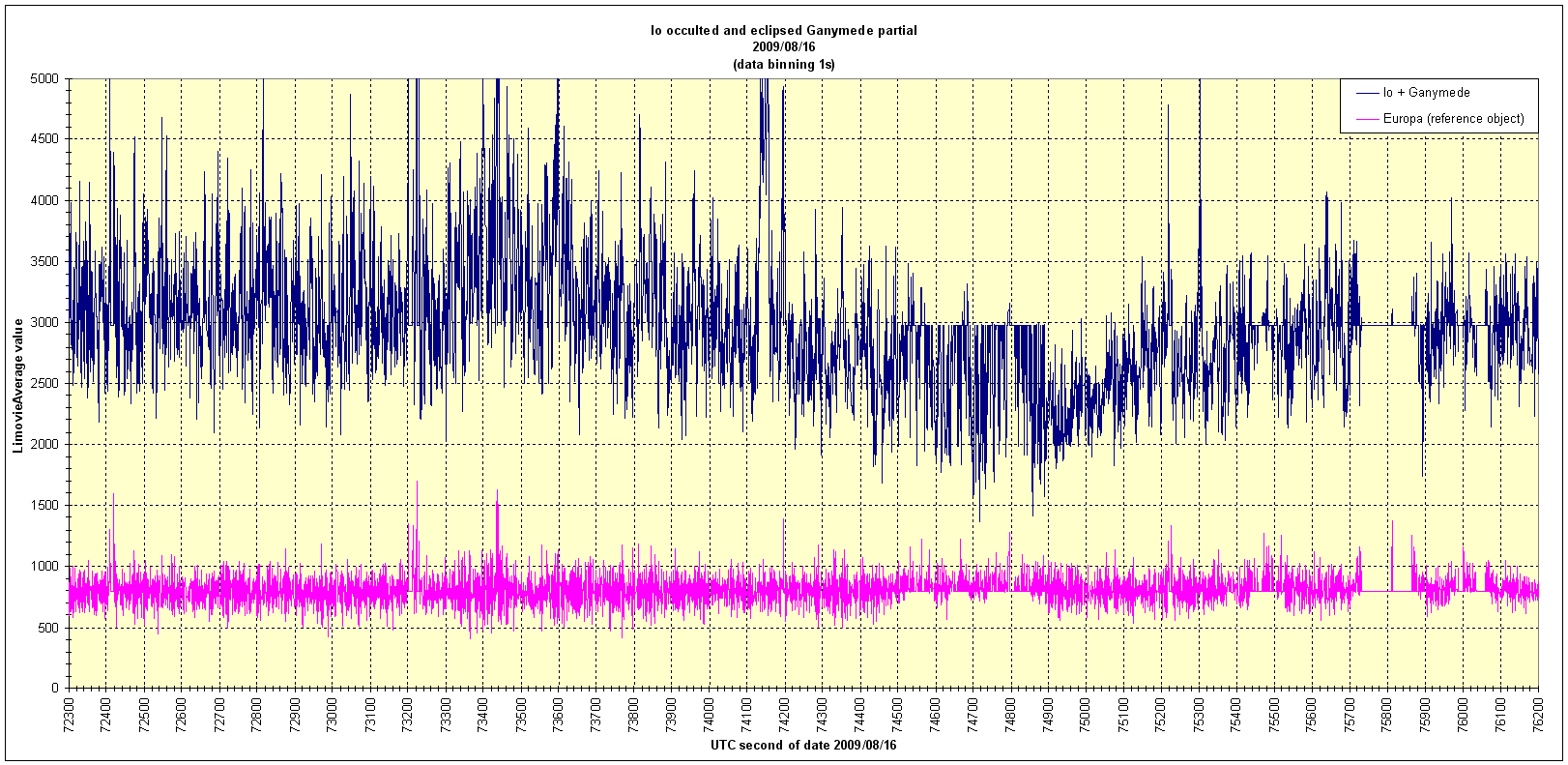 |
|
Diagram binning 2 seconds - click for full size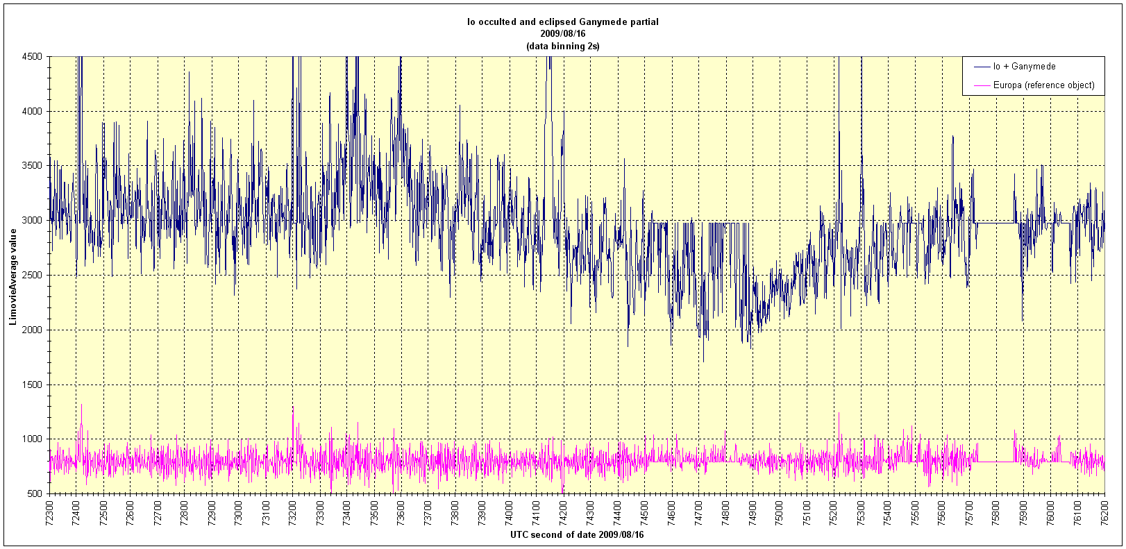 |
|
Diagram binning 4 seconds - click for full size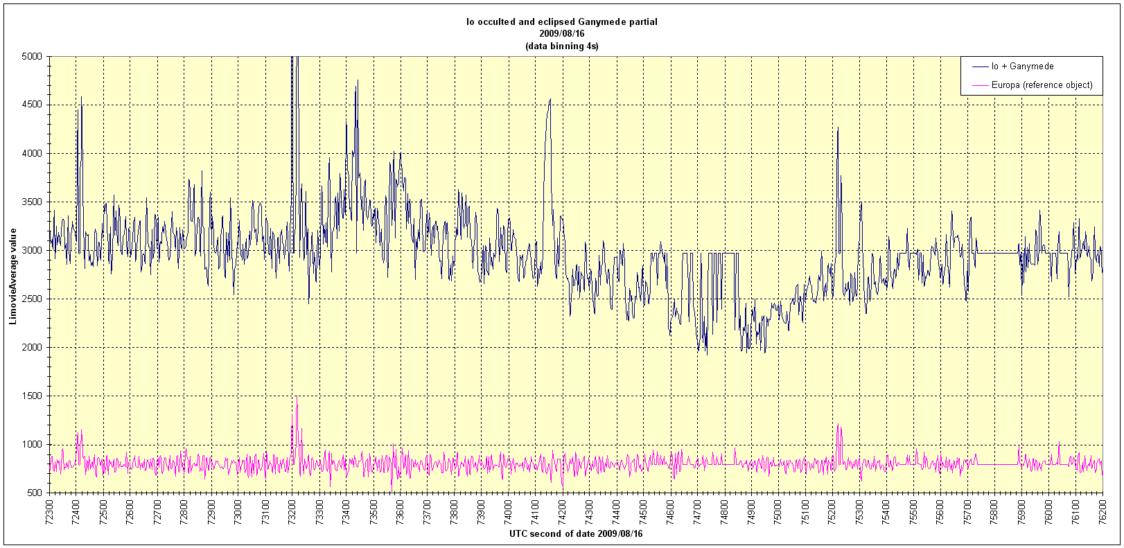 |
September 29, 2009 |
|
Site Home |